
Baljuri 5922m, Kumaon Himalaya: An Alpine Style Attempt in Winter

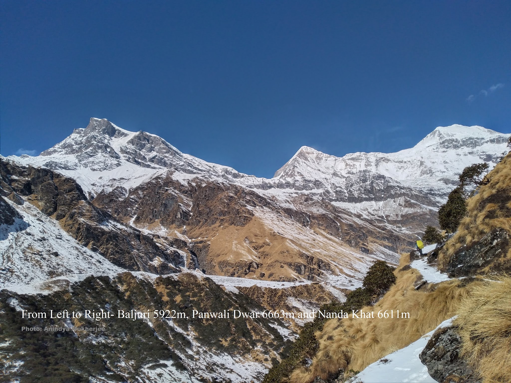
During the 2nd and 3rd week of December 2020, a team of 4 climbers made an attempt to climb Mt Baljuri 5922m in Him-Alpine style by the Baljuri col-North ridge route. The expedition did not use the services of any HAP or local guide beyond the traditional base camp of Baljuri and adopted a fast and light ‘carry, camp and climb’ style. The team reached Dwali (2610m) on 12th December and used two alternate ferry days via Phurkia (3189m) to station themselves at the traditional Base Camp (3600m) site of Baljuri on 16th December. During the approach march, the team encountered fresh new snow from a kilometer below Dwali and half way up to the Zero Point (3750m) the team found the trail covered in 6 inches to 1 feet of snow. 


On 17th December, 3 climbers (Aniket, Rivu and Anindya) started climbing the spur that leads one to the traditional Camp-1 site of Baljuri. The spur was a mixture of frozen grass, mud and boulders under a thick and deceptive blanket of soft new snow. The trio reached the traditional Camp-1 (4160m) area after 6 hours of climb. The camp 1 site (4160m) itself was comparatively free of snow as it faces East and gets a lot of early morning sun. On 18th December, the three started pushing higher and very soon they found themselves between knee-deep to waist-deep snow on a gradient that ranged between 35 to 45 degrees. 


Signs of loose snow avalanches (sluffs- both dry and wet) could be seen in number of places. The going became increasingly slow as a result and finally after 5 hours of trail breaking and route finding through unconsolidated powder, the three could climb only 500 meters. The team decided to make a Bivi (Camp-2) at around 4600m and dug out a platform accordingly on the NE face of point 4800m (located approximately 800m SE of Baljuri col). 


On 19th December, as the three started climbing further up, to their surprise they found no change or improvement in snow conditions as hoped due to overnight freezing. As the team was getting very close (100m) to reaching a comparatively easier angled Névé of the Buria glacier, they encountered slab formations big enough to sweep them off the face. It is then the team decided to turn back immediately. The team cleaned the Bivi site and started a long and slow descent to the valley floor. They reached the traditional Basecamp by 5pm that very day and over the next two days hiked back to the road head Kharakiya (2253m). Every protocol related to Covid-19 was maintained while the team traveled through cities, towns and villages en route.


Team: Aniket Mitra, Rivusoumya Das, Ashish Chanda and Anindya Mukherjee. Duration: 7th December, 2020 to 24th December, 2020.


Comments

Popular posts from this blog

Zemu Gap from south: the first documented ascent

view of Kangchenjunga south summit and Talung peaks from Tongshyong glacier. Pic. Anindya Mukherjee Text & Photographs: Anindya Mukherjee Introduction The history of exploration around Kangchenjunga [1] , especially around its south, south east and east flanks; has always fascinated me. The classic journeys and adventures of pioneers [2] like W.W. Graham, John Claude White, Douglas Freshfield, Dr. A.M. Kellas, Harold Raeburn, N.A.Tombazi, Lord John Hunt and Paul Bauer ignited my imagination. The height of inspiration of course came from reading my hero Mr. H.W. Tilman’s account in the Himalayan Journal (vol. IX) on his attempt on Zemu Gap from south in 1936. The primary challenge of climbing Zemu Gap from south has always been its remote & complicated approach. Many failed just to reach the foot of this col. To add to that its apparently impregnable defenses took Zemu Gap to a next level of exploratory climbing. In 1925, Greek photographer N.A.Tombazi is sai

Sundardhunga Khal – The Goddess Keeps her Secret

Sundardhunga Khal – The Goddess Keeps her Secret George W Rodway and Anindya Mukherjee The Sundardhunga Khal and our route of attempt in 2015 The History Locating a practicable route into the Nanda Devi Sanctuary occupied a very respectable amount of exploration time and effort in the latter half of the nineteenth century and first half of the twentieth century. By the time W.W. Graham made spring and autumn journeys to Sikkim and spent the summer in the Kumaun region around Nanda Devi in 1883, a shift had just started towards looking to the Himalaya as a venue for sporting adventure. Graham and the Swiss guides that accompanied him this year planned an ambitious itinerary for their time in Kumaun. They attempted to penetrate, for the first time in recorded history, the Rishiganga gorge with an eye to ascending Nanda Devi. Not surprisingly the difficulty of the gorge, not infiltrated to its source (after many attempts) until 1934, forced them to reconsider the wis

TREK AROUND THE MAYEL LYANG- April 2022

  TREK AROUND THE MAYEL LYANG- NOVEMBER AND DECEMBER 2021 THE HIDDEN LAND OF MYTHICAL PARADISE OF THE LEPCHA PEOPLE IN NORTH SIKKIM   Trip Highlight:   Culture, Jungle trek, Monasteries, Himalayan Lake, Off the Beaten Path  Approaching the Kishong Lake MAYEL LYANG: IT’S MEANING AND WHAT IT IS ALL ABOUT ‘Mayel Lyang’ is a Lepcha term that literally means “mythical paradise” or “hidden paradise”. It is also referred to as ‘Ancient Sikkim’ by the Lepcha. They believe their immortal ancestors still live in the snows of Kangchenjunga, hidden. Here Ma (‘Maa)’ means hidden, ‘yel’ means eternal and ‘kyong’/Lyang means a village in Lepcha; therefore, ‘Maayel Kyong’ literally means a ‘hidden and eternal Lepcha Village’. Lepchas believe that seven immortal Lepcha couples live in Mayel Lyang. It is a paradise on earth. It is believed by the Lepchas that ‘Maayel Kyong’ is situated at the head of Dzongu. The Lepcha offer their prayers, ovations and salutations to Maayel Ky